The weather forecast was excellent and looked perfect for a bike ride. We assembled at St Martin’s Christian Centre for elevenses.
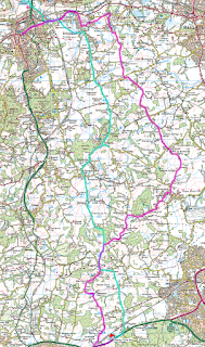
Fourteen riders were up for the ride and we set off. We went eastwards along A25 on a path next to the dual carriageway towards Brockham. We turned off A25 towards Brockham and took a left turn before reaching Brockham. This is a minor road leading to Betchworth. We went through Betchworth towards Leigh, Before reaching Leigh, we turned left and went through Leigh towards Charlwood. Reaching Charwood we turned right towards Rusper. This area is some of the most attractive countryside in Surrey. Going towards Rusper, you pass into West Sussex. We went through Rusper turning right. Then there is a lovely descent for about a mile. Then we took a left turn onto a very minor road which eventually reaches A264. Again, the countryside in this area is very pretty at this time of year. Although A264 is a very busy dual carriageway with fast moving traffic, there is a margin at the side of the carriageway where it is possible to ride safely in single file. After about half a mile on the eastbound carriageway we reached The Cherry Tree pub, our stop for lunch.
The meals and at The Cherry Tree were excellent (anyway, this is the opinion of the leader), and considering the number of people wanting a lunchtime service, the service was excellent too. Although the selection of draught beers was limited, the selection of lagers was good. I don’t think anyone was disappointed. I think that this might have been the first time that a Wayfarers group has visited The Cherry Tree (worth another visit in the future).
After lunch, we set off down A264 and turned off left and went through Faygate, then back to Rusper, then to Newdigate and Brockham. At Brockham, we took a track across Betchworth Park golf course. There was some speculation about how much the club fees might be, but we didn’t stop to find out. Then back onto A25, then through to Denbies’ winery for tea.
Finally, I am grateful to Tim who backed-up for us. When we split the group during the afternoon, Peter Tiller volunteered to back-up the leading section. Later, Peter took over the lead because the designated leader was suffering with cramp. Then there were the volunteers who marshaled at corners, roundabouts and crossroads. Getting good back-up and marshalling support is essential for a successful ride.
Peter Carpenter Peter used the Dorking start to lead us quite a bit further south than we normally go, a round trip of 33.2 miles and about 1492 feet of climbing.
Further to Peter's account of the ride we were pleased to welcome two new riders, Liz Neville, a marathon runner who has now seen the light and wants to prepare for triathlon events, and Brian Omarra who probably found our pace a little too fast in the hills but would have cycled, by my estimate, a good 70 miles by the time he got home.
Note that for the measure of climbing done I have taken to importing the GPS data into RideWithGPS and refetching the elevation data, the data which is embedded in the google map. This eliminates the 'noise', the wild fluctuations which occur in the raw GPS data recorded by my phone. No doubt it introduces other inaccuracies but I am fairly confident that it is more reliable, though sadly less impressive, than the raw data.

~ Tim


No comments:
Post a Comment