Tony's ride last week to the source of the Wandle interested me, but I wasn't convinced that the Wandle Park 'source' really was the source. Working out where it might be has provided a couple of enjoyable days research, some puzzling as to how it all fitted together, and a good ride to see it on the ground. It's an interesting puzzle, and here's what I found.
I started at the same place that Tony took his picture of the Wandle, but mine is from a different angle. As you can see, the river emerges from a man-made culvert, so that is hardly likely to be the source, even though several authorities say that it is. The source would more likely be where it went in to the culvert, or further upstream again.
A bit of investigation revealed that the culvert used to end beyond Waddon Ponds (another 'source'), and this piece was opened up in 2012 as a water feature for the park. But where did it start?
A few hundred yards from where I started is the Wandle Arms, and the street behind it is called Bourne Street - remember that, we'll come back to it. Around the corner is Rectory Grove, and the culvert is underneath it. The houses here were built in the 1880s, prior to that the river had flowed in the open.
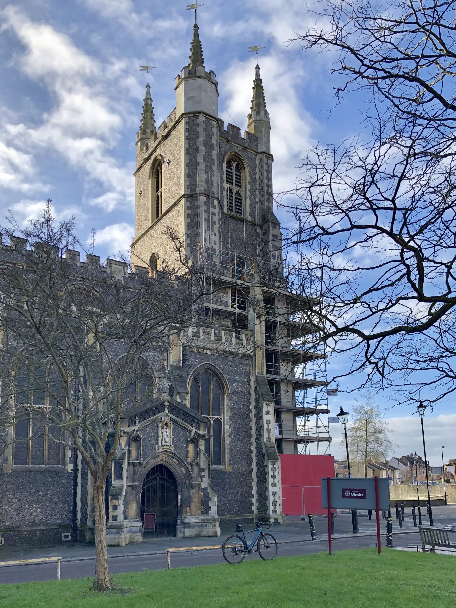
Down Rectory Grove, under the bypass, and we come to the Old Palace and Croydon Minster. There are some very interesting clues here.
Taking the Palace first, this was the summer palace of the Archbishop of Canterbury for more than five hundred years. Henry VIII stayed there, and didn't like it:
and, if you look at the second picture, you will understand that he may have had some justification. My bike is parked at the side of the Minster near where the river would have flowed, by a piece of grass that might have been a graveyard. But it isn't - all of the graves are on the other side. The reason is that, in times of flood, the coffins buried on this side would float up. Spooky. But how on earth did the feeble Wandle flood to that extent?
The answer is the bournes - the Caterham Bourne and the smaller Coulsdon Bourne. A bourne is an occasional river, found in chalk landscapes, and the river flows from time to time in the dry river bed under which it otherwise exists. These flows occur every seven to ten years, can be large and last for several weeks, occasionally even longer. The bourne was known as the "Woe Water" in Croydon, with good reason. As was common until Victorian times, the Wandle did double duty as water source and sewer, so when the bourne washed this lot through the town water borne diseases - typhoid and cholera - were not far behind.
On up the road, and fast forward to Victorian times. Up Southbridge Street - the bridge over the Wandle, of course - then I stopped at the Swan and Sugarloaf, another 'source of the Wandle'. There is said to be a spring in the cellar. It's a fine, confident building, built in 1896, but contemporary photographs show no sign of the Wandle.
Which is odd, because the 1856 Ordnance Survey map shows the river, running above ground, all the way to Purley. So what happened here?
I think that the answer lies in the improving zeal of the Mayor and Corporation of Croydon. Croydon knew that it had a problem with both fresh water quality and with waste water, exacerbated by the flooding from the bournes. The Wandle was placed in a culvert, starting at Purley, to take it well past the town to the other side of Waddon Ponds. It was effectively relegated to the role of sewer. A new fresh water supply was provided from an underground reservoir built in Croydon Park. Croydon was early into these improvements, before London's enormous works of the 1860s and 1870s, and they were effective. The bourne no longer flooded the dry valley from Purley, and the town no longer flooded.
So I rode on, up the Brighton Road, the road being on top of the culvert, until I got to the road over Riddlesdown, where I rode up the hill, leaving the culvert behind. This is the old Brighton Road, and is Roman, confirmed by archeological investigations. It's a good ride, with fine views, but it does beg the question why the Romans went over the hill instead of up the valley and round the corner. I have two suggestions. The first is that it's about a mile shorter, and second is that the confluence of the two bournes at Purley may well have been marshy - the Wandle did rise there, according to the Ordnance Survey.
Had I come this way in 1904 I could have met Mr W W Swatland, who was testing the depth of water in the yard of his pub, the Rose and Crown, on the Godstone Road. The bourne was running and the water was eighty feet deep in his well. That's a lot of water.
On towards Woldingham, where modern bourne defences are to be seen.
This is a levee and sluice erected to control the flow of the water. You can see that the intention is to trap the bourne flow in a pond, and to regulate the flow from the pond by means of the sluice. When tested with a real bourne in 2014 it was utterly ineffective. The bourne filled the pond more rapidly than the sluice could empty it, poured over the top of the levee and flooded the valley to Purley. But the Victorian culvert then dealt with the water flow, and there were no floods below this.
A short distance further on is the railway viaduct, which most Wayfarers know well, and I parked my bike against a Coal Post.
Things have changed a bit over the years, but you can see that it's the same place as this 1904 photograph, a significant difference being that the bourne is pouring down the road.
The last piece of the puzzle is Bug Hill Farm. The well here is 125 feet deep; it can dry out in a hot summer, and the water flows over the top of it when the bourne runs. That's a huge variation in water table.
This is where the Caterham Bourne starts. As far as I've been able to find it doesn't choose a particular spot, but I may be able to check this shortly, as it's seven years since it last flowed ...
So where is the source of the Wandle? Well, it's somewhere between here and Wandle Park, depending.
Mark


7 comments:
Hope I'm not the only one who did'nt know what a coal post was? Just found out,
Thanks Mark. Quite an education here. Prompted by your article I looked at the public information on the Wandle flood plain (https://riverlevels.uk/flood-warning-river-wandle-catchment. It doesn't extend south of Croydon but does include some surprising areas closer to home, including much of South Wimbledon, the Don's new stadium-to-be at Plough Lane and parts of St George's Hospital, though thankfully not the helipad. Not to mention the Norbury Brook (aka River Graveney) up to Thornton Heath. Quite an eye-opener.
A very interesting geography and history lesson thanks Mark. We take so much for granted without thought of the engineering behind it that stops us being seriously flooded or catching typhoid. I’m not sure what the Romans did for us but the Victorians did a lot! 😃
Fascinating detective work, Mark. In the first lockdown, I followed the River Crane from where it joins the Thames at St Margarets to its source, another green corridor through suburbia but with fewer cycle paths than the Wandle. As in your experience, it gets interesting as you get near the source where the river disappears but evidence of it (willow trees, dry valleys and so on) is still clear. Then, over the hill, and you meet the source of the river Brent coming the other way. Neither of these are suitable for a Wayfarers ride, I discovered, but it does make an interesting solo ride.
Thanks Mark. A very exhaustive study and exploration. Once these bournes get buried they tend to be out of sight and mind until the next very wet spell. Sometimes these are regular ( the Winterbournes of which there are many) and some where the lack of action after seven years doesn't mean never.
I used to use the A31 between Guildford and Winchester. Never a problem for 20 years until after the autumn of 2000. A few months later ( after the rain had soaked through the chalk) the A31 disappeared at Ropley under a foot or more of water. It was closed for weeks.
Very interesting, thanks. As a further episode, how about a trip along the route of the former Surrey Iron Railway which must have run parallel too, or overlapped with some of this route?
More information on the goings-on around the source (or not) of the Wandle here: https://insidecroydon.com/2024/10/06/brewers-business-empire-that-flowed-with-the-river-wandle/
Post a Comment